
Written By a Dummy, FOR Dummies...
To better understand how leasehold and various Field Rules affect development of tight oil resources, lets take a little walk thru the infamous, Phantom (Wolfcamp) and Phantom (Bone Springs) Fields in the Delaware Basin of West Texas.
There are almost 5,500 wells in Phantom Field and so far those wells have produced 1.4 billion barrels of light, tight oil, 6.3 TCF of associated gas and a Lake Superior of produced water.
Hopefully this will help understand the complexities of mineral leasing and how laterals must be drilled to conform to applicable Field Rules in Texas. Well quality IS declining in the Delaware Basin and its getting very crowed out there already. The tight oil industry always has the next, big hope at its finger tips and one of those hopes is longer laterals and, naturally, more wells.
Easier said than done, on both counts, as I hope to show.
Part One: 'We Don't Need No Stinkin' Regulations'

The Delaware Basin in Texas and New Mexico contains 18,300 HZ tight oil wells in it, 85% of which are drilled to two benches in the Wolfcamp formation and two benches in the Bone Springs formation. The productive limits of the Basin are now fully delineated; it is bounded to the east by the Central Platform, to the West by much higher gas to oil ratios, to the south by increasing water to oil ratios and to the north by shelf margins.
In all field and/or resource plays the best core areas and the best productive benches are drilled first. An example of well quality outside the productive limits of the Basin might be found in the Alpine High area in Culberson County were wells are very, very gassy and the vast amount of liquid hydrocarbons that were promised have been a gross over exaggeration of the truth.

We should immediately dispel the false claim that the inability to lease Federal BLM land under this current presidential administration hurts the Delaware Basin HZ play in Texas; it doesn't. It might hurt New Mexico, though New Mexico has had 40% of the total rigs running in the Permian Basin for the past three years, but it dies not hurt Texas. There are 429,000 acres of Federal leases available in Texas and in 2020 less than 180,000 acres were actually productive and, for the most part leased and held by production (HBP). Federal leasing in Texas is N.A.


In Texas they're actually packing HZ wells into the Delaware Basin in the Phantom Field(s) on 330 foot spacing, like sardines in a can. With 40 acre tolerances in Phantom Field Rules, operators can actually sneak an extra well in a unit as close as 50 feet away if you need, you know, to piss some more money off.
In terms of well spacing, anything goes out in the wide open spaces of West Texas; an operator is confined only by the fact that every other sumbitch in Texas wanting to drill horizontal oily gas wells is your neighbor and leases are jammed together like homes in a DR Horton subdivision. There is not 10 square feet of productive Wolfcamp and Bone Springs minerals in Reeves and Loving Counties that is not leased or held by production.

Here is a Texas Railroad Commission GIS map of a little area of Reeves County in the Phantom Field(s). I have arbitrarily picked a specific a 1280 acre "pooled" unit put together by WPX in 2015 and later bought by Devon, to simplify the points I wish to make. This particular drilling unit now has nine wells drilled on it and Devon is cramming more into the Unit, called "Herc State."
When looking at these kind of GIS maps remember the little octagon symbol suggests a surface location, the line is the lateral and at the end of the line a little dot representing the toe of the lateral, or the terminus. GIS maps are not very accurate. Each square in these maps is roughly a 640 acre section. Some horizontal laterals as you can see were short, and confined to one section, most longer and to two sections. It generally takes 3 leased sections stacked north south on top of each other to drill a 15-18K foot lateral in the preferred north south orientation. In the section of GIS map above I see no laterals longer than 10K feet. Looks like there is lots of room for more wells in this area, right? See below.*

Here is the same Herc State Unit area in the heart of the Phantom field, to a different scale, on a Tcxas General Land Office (GLO) map, without wells, showing sections of lands, sections divided into half and quarter sections and how the land was subdivided hundreds of years ago along both sides of the Pecos River separating Reeves and Loving and Ward Counties. Many of these sections, etc. contain minerals that are owned by private owners, large mineral trusts and/or partially owned by the State of Texas. In Texas minerals can be severed from fee ownership and can also be severed by virtue of vertical depth. For instance, Shale R US, LLC might have the surface to 12,000 feet leased and Tight Oil City, Inc. all depths below 12,000 feet. Royalty ownership can also be different than mineral ownership. When performing the most elementary of oil and gas land work, petroleum "landmen" have to have IQ's in the mid 150's, have plenty of patience and tend to play lots of golf while drinking multiple beers.

For example, here is the same area on the same GLO map to a different scale. From this map its possible to sort out who owns what minerals, who has those minerals leased and other pertinent leasehold data that clearly shows what a mess this all is in the 100 year old Permian Basin.
Lots of minerals in West Texas are still owned by the Texas Pacific Railroad Land Trust (3,500,000 acres); over the years Chevron acquired over 500,000 additional acres of the TPLT minerals. Other minerals in West Texas, millions of acres, in fact, are owned by the State under the Relinquishment Act of 1931 (RAL) whereby surface owners have the right to lease State minerals, and be compensated, providing the oil, gas and mineral leases are acceptable to the Texas General Land Office. RAL minerals affect 7,400,000 acres in West Texas. RAL land minerals are divided 1/2 State, and 1/2 fee owner, unless those minerals were sold by private parties and are now owned by 3rd parties, which is often the case. Sections of land can often have countless different mineral and royalty owners all of which must be precisely to the proper decimal interest. I use to own royalty in West Texas drilling units whereby my interest was something like 0.002789 of 8/8ths. It would take you at least a 10 hour day to sort this all out in this little piece of GLO map.
Different Lessees are all vying for their share of the big Wolfcamp/Bone Springs pie and it is not a "community" effort to simply drill baby, drill wherever there is a blank spot, nor is it easy to drill longer laterals in areas that were initially leased, and drilled, based on shorter laterals. Folks do some really dumb stuff to work around that.
Part Two: What You Can't See Won't Hurt You

Above is the most relevant page in the final, 2015 TRRC adoption of current field rules for the Phantom (Wolfcamp) Field in the Texas part of the Delaware Basin. There are couple of things interesting to learn from this exhibit, above:
1.) there are no specific rules for various A,B, C or D benches within the Wolfcamp formation. The entire correlative interval from 9,500 feet vertical depth to 12, 500 feet vertical depth is considered one field. In other words, there is NO spacing requirements between various benches in the Wolfcamp and the TRRC does not care, nor keeps track of where the lateral is placed as long as its in the Wolfcamp correlative interval and those wells are 330 feet apart. I did not pull the Field Rules for Phantom (Bone Springs) Field but I suspect that it too covers a correlative interval over the entire Bone Springs stratigraphic interval.
2.) in Rule 2 you get some idea of how little regulatory "confinement" these tight oil folks have; they can essentially ask for, and receive, anything they want from the TRRC, and do, often. The definition of the prevention of waste is qualitative and pretty much up to the three TRRC Commissioners to decide based on the hearing examiners findings of fact and recommendations. Shale R Us, LLC can argue before the TRRC that oil will get left behind if it is not allowed to drill a well between other wells 330 feet apart and an exemption to the applicable spacing will almost always be granted.
Or, Shale R Us, LLC can claim Tight Oil City, Inc., for instance, has drilled a well terminus an illegal distance from it's lease line and to prevent confiscation of property (minerals) or to keep from being drained (mineral trespass) , it wants to drill a well an equal distance from Tall City's lease lines...and off they go again.
When the tight oil sector whines about being "unleashed," it can't be talking about regulatory spacing and well density constraints. It effectively has the "flexibility," to over-drill itself to death, which it more or less, has. Other peoples money makes otherwise smart people, really stoopid.
In Texas there can be unitization of numerous leases, subdivisions of leases, combination of leases (different than unitization), pooling of leases (New Mexico), which is different than unitization and/or combination, production sharing agreements between different Lessees/operators and even something called "allocation wells," where operators can drill laterals across acreage they don't even have leased, the legality of which has still yet to be determined in Texas. If you think there is not a bunch of chicken fights between offset operators about drainage and mineral trespass, illegal terminus or penetration points, about take points along a given lateral...google the TRRC's hearings docket on its website. Regulatory lawyers go around the clock in Austin at $400 plus dollars an hour trying to keep operators, royalty owners, mineral owners, surface owners, etc. etc. from killing each other.
Part Three: Sardines In a Can

Above is a shaleprofile.com production profile chart for wells on the WPX, Herc State Unit and an actual map of the 1280 acre drilling unit.
* Please note 2020 wells are not doing as well as the initial 2018 wells are they? Its a common theme out here and related to over-drilling and ensuing pressure depletion. In the case of the Herc State Unit, 2020 wells are much poorer that 2018 wells, an example of drilling Tier 3 level stuff within the confines of an existing unit, 330 feet away from one- time Tier 1 wells. Drainage is a bitch.
Its a nice quick-look map by shaleprofile, above, and likely more information than anybody would ever need. But lets carry on into the rabbit hole and look at a surveyed plat of the Herc State Unit and the W-1 Application to Drill, filed with the Texas Railroad Commission, for the the 434H, in the Phantom (Wolfcamp) Field and a plat of the Herc State Unit. Click on any of these images to enlarge.


Above is the surveyed plat for WPX's Herc State 1280 acre unit in Reeves County, prepared by a registered civil surveyor on behalf of WPX and filed in conjunction with Forms W-1. The bottom section, called Cedar Mountain (Section 15 in Abstract 788), has one, short lateral well drilled on it initially, likely a sort of lets-see-what-we-got-well. The Herc State 640 acre section (6) had a permitted, short lateral well on it that was never drilled.
The Herc State section was then pooled with the Cedar Mountain Section to form the unit and subsequent 8,000 foot lateral wells were drilled with identifying well numbers. Squiggly laterals very close together or likely Bone Springs wells filed in the Phantom (Bone Springs) Field, or a different TRRC field designation. Wolfcamp wells, however, outlined on the plat, are clearly 330 foot part, or more. The dashed red line located 650 feet from the west unit line is the proposed permitted lateral, No. 441H. If the Cedar Mountain 1H is still producing, the 441H will be granted under a Rule 37 exception to existing field rules, or one lateral is in the Bone Springs, the other in the Wolfcamp.
In the plat above you will see there is SHL location in the bottom part of Section 15 with four vertical, radiuses headed south into the adjoining, underlying section, whose Lessees are unknown.
Part Four: Making the Most Of It
How do you maximize lateral length when you only have two sections leased, one on top of each other, like WPX?
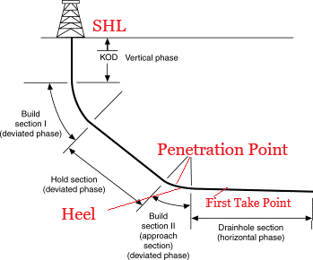
SHL stands for surface hole location. That is the pad site and in this case it is actually located on a WPX leased section. The vertical and radius sections of those wells from the SHL, however, are drilled to the north, north, north east and north east actually onto the unleased section owned by Anadarko (Oxy). This allows the well bore to reach chosen vertical depth in the Wolfcamp formation. That means the horizontal lateral in the Wolfcamp was actually penetrated off lease, called POP for point of penetration. Once the lateral penetrates the Wolfcamp and its orientation is headed south, the lateral is primarily on WTX leasehold. But the first "take point" in the lateral, called FTP, or the last stage of the lateral nearest the heel to be stimulated, cannot be perforated unless it is a legal distance from lease lines. In the case of the Phantom Wolfcamp Field, that distance is 100 feet. The toe of the lateral, or the terminus, or bottom hole location (BHL) is suppose to also be 100 feet from lease lines. The 441H is proposed to end 50 feet from the south line. Don't ask me how.

If you are limited, or bound by leasehold restraints but wish to maximize lateral length, you have to rely on the good nature of your neighbors and be prepared to pay out the nose for the privilege. Otherwise you might loose 1000 feet of lateral length on your two section leasehold and leave oil stranded. Radiuses are not 90 degree angles, but long, swooping curves. This WPX stuff would have to have had Anadarko's approval, of course, and or the General Land Office, to drill across another adjoining mineral estate. In many cases the SHL can actually be off-lease, on your neighbors place, with special permission (and lots of rental costs, etc.). The POP can then also be off-lease, but again, the first take point in the lateral has to be 100 feet from the lease line.
Dashed lines representing a proposed lateral in a W-1 filing never end up being straight and subsequent post drilling surveys must be done that show where the lateral actually might have wandered, where it ended, etc.
Above, an Anadarko plat on its Chicane State Unit where it has 3 sections under lease but as elected to drill shorter laterals. Feel free to sort this shit out, if you want.
Part Five: Bigger is Better ?
Frac engineers want you to believe they know exactly the extent the rock that is being stimulated (SRV for stimulated reservoir volume) but don't kid yourself, the wings on a frac (radius) are not predictable and that shit is wandering around out there finding the path of least resistance, including up, out of zone. We know wells are bumping into each other, or "bashing" each other when stimulated because children wells are underperforming parent wells by sometimes up to 30%. There is soooooo much money to be made out there that people are overlooking drainage between wells, outside lease and unit lines, and particularly drainage between benches, I promise.
Longer laterals can occasionally be wiggled in between existing medium to short lateral development, but when it involves different leasehold estates, production sharing agreements (PSA's) and/or lease consolidations and/or subdivisions (TRRC P-6) must be made between affected parties and shit really gets complicated. If Devon and EOG want to team up to drill a four mile lateral, a P-6 has got to be filed and an operator named. There then might be a hundred or more royalty owners in that PSA.
One of the probable reasons that Pioneer might have recently bought his son's adjoining acreage (Parsley), for instance was to be able to drill longer laterals. Pioneer says in its investor presentation that 10% of its 2022 wells will be longer than 10,000 feet; we'll see how much better those wells are.
I think densely populated core areas of Lea, Eddy, Loving and Reeves Counties currently have fewer that 5% of total wells that are longer than 10K feet. And I don't see how longer laterals can be squeezed into that big bowl of noodles.

When I look at longer laterals I see higher initial potentials but ensuing decline rates are much steeper; if longer laterals add EUR, its miniscule and hard to see in the data. I don't see much to write home to mama about, except higher costs. Above, for instance is a covey of 15,000 foot laterals drilled by Exxon over in Midland County in 2019 and how that covey stacked up to well performance by other operators over the years in that county, just about all of whom were drilling <9,000 foot laterals. Sucky looking, uh?
Part Six: What's The Point?
Leasing and mineral law in Texas is complicated. Forming drilling units that comply with Statewide Rules is really complicated and now you can get some idea of why an understaffed Texas Railroad Commission is always months behind. Mineral leases and regulatory rules, however lax they are, is a big reason why "technically recoverable resource" estimates per bench per square mile (USGS) is not very applicable in estimating the future of tight oil production in the Permian Basin. Its not "open range" out there in West Texas where you can just turn your cattle lose to graze on your neighbors grass.

"Lack of "blocky" acreage is one of the biggest constraints to longer laterals – companies may simply not have enough contiguous lands to extend wells out for three miles or so." SPC Global
I am telling you folks, all this hype about decades of more drilling in the Permian Basin is flat-assed wrong. March and April 2022 are seeing a big increase in drilling permits across the Permian Basin, I just don't see how much longer that can go on. Those dudes out there are running out of good stuff to drill, $100 oil covers lots of warts, but in a few years America will be cruzin' for a bruzin' with regard to future supply.
