"Nunca le pido a Dios que haga nada por mí, sólo le pido que me ponga donde están las cosas," is a very old Mexican proverb that I learned long ago and am quite fond of. My apologies to my Mexican friends for writing so poorly.
The proverb means, I never ask God for anything, I only ask that He put me where things are.
The history of the "Golden Lane" of eastern Mexico is rich in culture, social revolution and some of the world's most spectacular oil wells. I have written previously about enormous blowouts in this area that occurred in the early 1900's as tough, tenacious men from the United States, Europe and Mexico itself, explored for oil in the jungle and coastal plains of the Huasteca region along the Gulfo de Mexico. My narrative about the Cerro Azul No. 4, perhaps the largest oil producer the world has ever known, offers a brief glimpse into early Mexican oil history and can be read, here, on Oily Stuff.
Edward Doheny (1856-1935), a Californian responsible for some early oil discoveries in the Los Angeles Basin in 1900-1901, became aware of numerous heavy oil seeps, called chapapotes, in the region west and south of Tampico in Mexico and began leasing large blocks of acreage, then privately owned by Mexican nationals. Doheny was a seep believer; his first discovery in Los Angles was at the Brea Tar Pits. After numerous dry holes, Doheny found shallow oil in the Ebano area, some 40 miles west of Tampico in 1901 and again in 1904 at a deeper depth. The Ebano-Panuco Fields represented the first commercial oil production in Mexico.
Of possible interest to some, Upton Sinclair's book titled, Oil was based on the life of Edward Doheny, left, and the movie, Let There Be Blood was loosely based on his life.
Doheny's Mexican oil venture, Huasteca Petroleum Company, produced approximately 319.6MM BO in Eastern Mexico during the period 1902 to 1918 (DeGoyler).
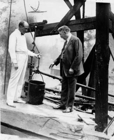
Doheny, right, at his first oil discovery in Los Angles; 1896

A typical asphalt seep in the area south and west of Tampico on the east coast of Mexico; circ. 1902

A British man named, Weetman Pearson (1856-1927), left, was building a railroad for the Mexican government in the early 1900's and looking for oil in the Huasteca region at the same time, about 135 miles south of Ebano, under the name, The Pennsylvania Company of Mexico, the predecessor to El Aquila Oil Company and ultimately the great, Mexican Eagle Oil Company. Pearson, later knighted, Lord Cowdray in England, produced 169.9 MM BO from Eastern Mexico during the period 1908-1918 (DeGoyler) and ultimately sold his company to Royal Dutch Shell.
When Pearson received news of Doheny's discovery in Ebano he jumped way north of his acreage positions in the Veracruz region, closer to Doheny's block, and drilled the San Diego del Mar Numero 1 well that had significant oil and gas shows in it before down hole tools were lost and the well was abandoned. Well No. 2 found 2,500 BOPD at 1,815 feet. The well produced for a week before turning to water.
On July 4th, 1908 in stifling heat and humidity, Pearson's men were bailing the San Diego 3 well nearby to the No. 2 when it blew out so suddenly and so ferociously it disintegrated the wooden derrick and blew most of the casing out of the hole. Before the drilling crew could get to the boilers to shut them down, the well caught fire. From the driller's log ...
"[W]ith a terrific roar of gas and oil and a clap not unlike thunder, which shook the earth violently, a solid stream of oil began to pour out with such a force that the drill and the pieces of casing over thirteen hundred feet of which were hurled hundreds of feet into the air while pockets of oil were formed in all directions...
...the workmen immediately put out the fire underneath the boilers but the oil, which the immense pressure had forced up along the outside of the casing and through fissures over the surface, ignited from the red-hot pipes, which were impossible to cool quick enough, and, within a few minutes, the well and surroundings was [sic ] a seething roaring conflagration beyond all control and from which the manager and laborers on the ground saved their lives only after great difficulty. The heat was so intense that it is impossible to go nearer than several hundred feet...
...considering the great quantity of oil coming out, there is little gas. The internal pressure is tremendous. The height at which the oil first ignites is forty feet. The steady height of the column of oil is 850 feet while gusts of wind are constantly deflecting the main flame and portions of the burning air to an immense height, oftentimes exceeding fourteen hundred feet."
Within an hour the San Diego 3 well was completely lost. Estimated flow rates several days later were 90,000 BOPD towering hundreds of feet into the air and spilling into the nearby Rio Carbajal and eventually into Laguna Tamiahua.

A note, please, on estimating old blowout flows into earthen pits, etc. Flow channels to earthen pits were sometimes dug with fairly precise dimensions so as to calculate barrels per inch, or centimeter, of ditch. Posts were set in the ditch and marked to gauge the flow rate.
At the request of Lord Cowdray, some 200 Mexican soldiers were sent to help control the well. They attempted to pump water on the fire and a tunnel was dug to gain access to the base of the fire, while dams and earthen ponds were built to retain some of the oil. The tunnel collapsed and that idea was abandoned. No oil well fire like this had ever been seen in North America and blowing out of little more than a hole in the ground, there was little to be done. A reward was offered to tame the beast and men from the Texas Gulf Coast, use to oil well fires and blowouts, came only to stand back in awe at the immensity of the fire. Black "rain" from the San Diego well fell as far away as Tuxpam, 40 miles to the south.

Above is a photo taken in late July,1908, when the well was still burning.This photo was shot from the Gulf of Mexico looking west across the Laguna Tamiahua. Ships sailing to Tampico and Veracruz could see the glow of the fire from 200 miles at sea.
The well raged on for nearly two months, the crater around it getting bigger and bigger. The absolute open flow rates, up little more than a giant shaft in the earth, must have been staggering. A second crater was formed, and grew, and ultimately the San Diego No. 3 well became known as the Dos Bocas well, meaning "two mouths."
On day 57 and 58 the well starting turning to water. The fire was extinguished, the well loaded up and bridged off, dead. An estimated 1MM barrels of oil was recovered from earthen pits and an untold amount of oil was burned from the nearby river and laguna. The crater continued to grow as very hot, salt water, some oil and H2S ridden gas bubbled for years after the well bridged off. Several hundred acres around the crater looked like a wasteland.

Legendary geologist and eventual founder of the American Association of Petroleum Geologists, Everett L. DeGolyer (1856-1956), began his oil career in eastern Mexico in 1909 working for the El Aquila Company and Weetman Pearson. Mr. DeGoyler was able to correlate the existence of asphalt seeps with outcropped faults and topographical highs in the Huasteca region.
As more wells were discovered along a north to south trend and "Mr. De's" study of the subsurface progressed, he was ultimately able to map a reef-like atoll feature, in the Tamaspo Formation (Ebano and Panuco Fields). That trend was ultimately called, The Golden Lane.
The Tamaspo Formation is a Cretaceous-age carbonate with tremendous porosity, often over-pressured and over temperature gradients for it's 1,800-2,000 foot depths, most likely associated with deeper volcanic basalt. When one of DeGoyler's wells blew out in 1911 in the Potereo area, south and west of Dos Bocas, it hurled large chunks of reef and stalagmites, similar to those found in a cave, 300 yards from the well. Volcanic activity in earlier geological time is believed to have played a role in the "leaching" of the Tamaspo limestone and helped create its tremendous porosity.

Between 1910 and 1914 Mr. De wrote a paper entitled The Oil Fields of Mexico With Particular Emphasis on the Tampico-Tuxpam Region that contains over 500 pages of detailed surface, subsurface mapping and analysis of every well drilled in the region until the time of his final departure from Mexico in 1917, including well logs and estimated well productivity. Above is DeGoyler's narrative about the San Diego 3 well and a time sequence "drawing" of how the Dos Bocas crater grew over a four year period.

El Aguila office in Tampico, circ. 1916
Four to five additional wells were drilled surrounding the infamous San Diego blowout and no commercial oil production was established. Mr. De was of the opinion that, although the controlling structure of the Dos Bocas event was massive and contained possibly 50-60MM barrels recoverable oil, the intrusion of bottom water from the blowout ruined its probability of production, stranding that oil forever.
When Edward Doheny got wind of the Dos Bocas blowout he leaped frogged Pearson's acreage block to the south some 20-25 miles and made very good discoveries at Casiano and ultimately found the Cerro Azul 4 monster, all in the same Tamaspo formation.


Mr. Everett DeGolyer was directly involved in drilling arguably one of the most productive oil wells in oil history in 1910, south of the Cerro Azul No. 4 well, the Potereo No. 4.
Below is one of his many drafted base maps for the Tampico region of eastern Mexico. Areas shaded in red are believed to be El Aquila (Pearson) acreage positions; the location of the three most famous wells in the area were added by the author.


After arriving in Tampico by train in 1909, Everett DeGoyler took a panga down the Laguna Tamiahua, south toward Tuxpam. He stopped at a little fishing village and hired a burro to take him a mile inland to the Dos Bocas crater where he took this photograph. He was reportedly startled by the magnitude of environmental damage surrounding the well are remarked that the area seemed "lifeless."

Courtesy University of Alabama
Please click to enlarge
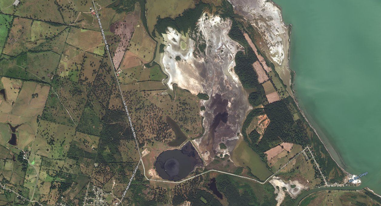
This is a satellite image of the Dos Bocas blowout crater taken in January of 2020, 113 years after the event. The primary crater is in tact and, in fact, still bubbling and emitting a foul H2S odor. In its center, in the deepest water, is the approximate location of the wellbore itself. The crater is approximately 1400 feet across at its widest point. To the right of the crater we can see where a dam was thrown up long ago in the containment operations. Sadly we can also see where 75,000-90,000 BOPD of crude oil, blowing for over 50 days, spilled into Laguna de Tamiahua and south in the Carbjal River. The scar of this blowout will never go away; it is now a permanent part of the Mexican landscape.

Image of the Dos Bocas blowout crater, 2015.
The shear magnitude of the great Dos Bocas fire frightened villagers for hundreds of surrounding miles and many believed that this fire represented the end of the world. A witness to the blowout, a man named, Juan Palacios said in his small book called, Memories About the Fire Of the Dos Bocas Oil Well, written in 1912, described what he saw in this paragraph...
"The smoke slowly grew in sight, fringed in moments by flames, like a monster of dark hair crowned by a wide and glowing fire[...]
[…] the oil well of the Huaxteca has cast during the period that lasted its combustion [...] a stream that bubbled in the center of the crater, all of it seized by liquid and flames having reached a diameter of 280 meters; this stream overflows in a cascade over the immediate swamp, producing, according to the more moderate calculations, no less than 100,000 barrels per day [thus turning the oil well into the] richest in the world, and the fire [into] the most terrible ever produced in nature."
I believe this Dos Bocas event to be one the most important in all of Mexico's amazing oil and natural gas history. It was, for a lack of a better description, the Spindletop of Mexico, and led directly to massive discoveries along the Faja de Oro, including the development of the eastern rim of the reef atoll in shallow water in the Gulf of Mexico thru the 1960's. The Golden Lane is reported to have actually produced somewhere in the order of 2.18G BO to date.
References
[1] DeGolyer Papers, The Everett DeGolyer Library at SMU University
[4]Gray, Peter; Oliver, Kendrick (2004). The memory of catastrophe. Manchester; New York: Manchester University Press
[6] Weetman Pearson, Wikipedia etal publications
[7] The Oil Fields of Mexico, Everett DeGoyler; The Everett DeGoyler Library at Southern Methodist University

The golden era of Mexico's Golden Lane oil development occurred between 1910 and 1920, at the height of the Mexican revolution. The big fella in the middle is Pancho Villa, surrounded by some of troops. General Villa led the revolution's northern campaign, along the "big river," and including the Tampico region of eastern Mexico where the Faja de Oro exists. Many of Mexico's oilfields, owned and operated by foreigners like Doheny and Pearson, had to be protected constantly from revolutionists like Villa fighting against oppression of the Mexican working class.