Test Your Geological Skills
Click to enlarge
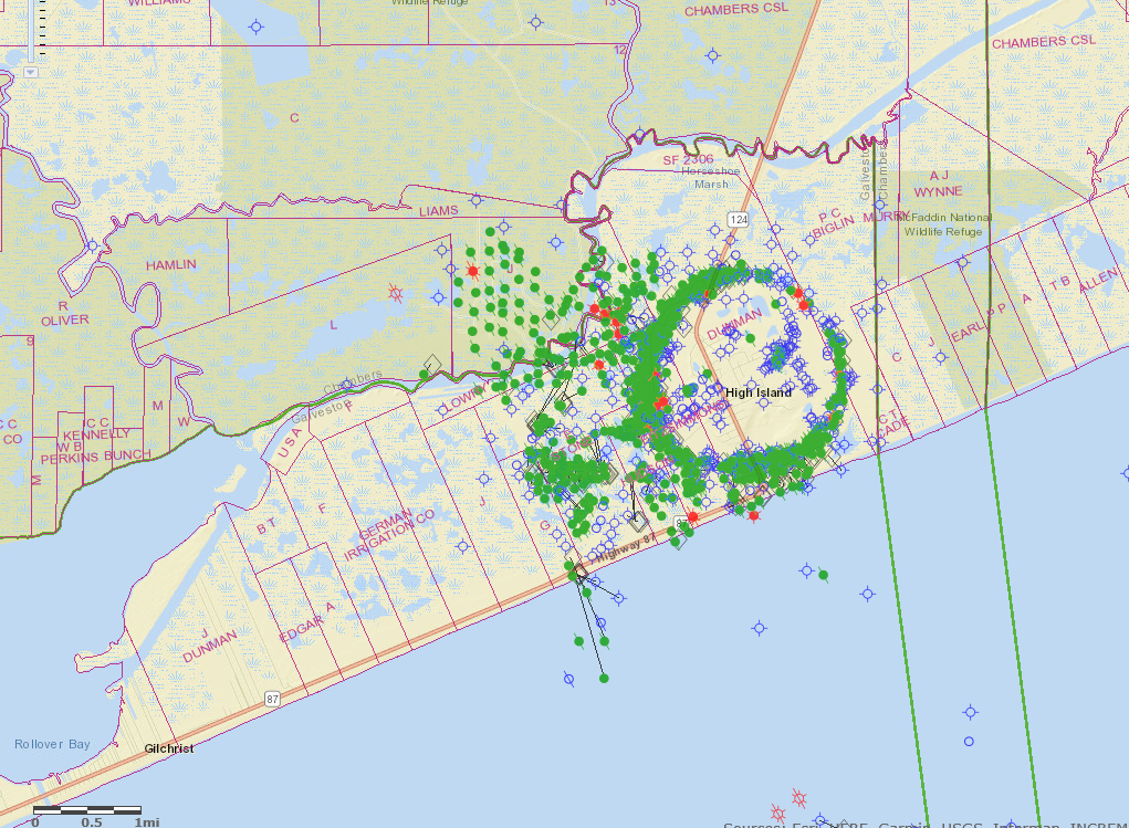
The symmetry of oil wells (green dots) located on this GIS image along the Texas Gulf Coast east of Galveston is indicative of...
a.) an inside-out waterflood pattern
b.) pig-headed mineral owners who held out for higher lease bonuses
c.) structure on the upthrown side of a down to the beach fault
d.) facies changes on the west flank of a syncline bifurcated by Highway 124
e.) a salt dome
_________________________________
If you chose e.) salt dome, congratulations; you are correct. We know it doesn't have anything whatsoever to do with shale but it's important to know these sorts of things anyway. Someday your grandkids may ask you who Moby Dick was, or what a salt dome is, and you need to be able to answer these sort of questions like you know what the hell your talking about.
____________________________________
High Island Field consisted of Pliocene and Miocene age clastic sands pinched out against a salt pillar. Salt was evident in shallow depths and no productive sands were "draped" over the top of the pillar, thus the lack of wells in the donut hole. Wells drilled off to the west and northwest were drilled thru the salt overhang to deeper Oligocene sands, an example of that can be seen, here.
The field was poked around on as early as 1902 (based on a surface high and gas seeps in nearby marshes) but was not formally discovered until 1922, by a fella named W.C. Patton. Amoco did most of the early developing. The field's total production has been something in the order of 163,000,000 barrels of oil, roughly equivalent to the UR from 954 Eagle Ford shale wells.
There are actual producing wells still on the beach at High Island, even today. One need only imagine how many times the past 97 years these wells were completely underwater in storm surges and/or buffeted by 150 mile an hour hurricane winds. They were resurrected from the dead time and time again and put back on line...the Texas way.

High Island Oil Field